
Forgotten Hillfort and LiDAR
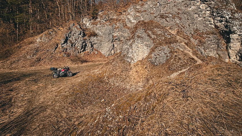
The first signs of early spring practically force us to step away from project work and head into the field. Winter is not the happiest season for motorcyclists, but when it comes to exploring the surrounding area and its past, the lack of sun, cold temperatures, and snow paradoxically have their advantages. During this period, as sunlight returns, the vegetation cover that effectively hides traces of the past disappears.
Buildings overgrown with ivy become more visible, as do elements hidden in tall grasses, and — most importantly — the hardest-to-spot medieval and prehistoric remains of mounds, hillforts, or settlements. It was precisely this last type of object that defined our Saturday route.
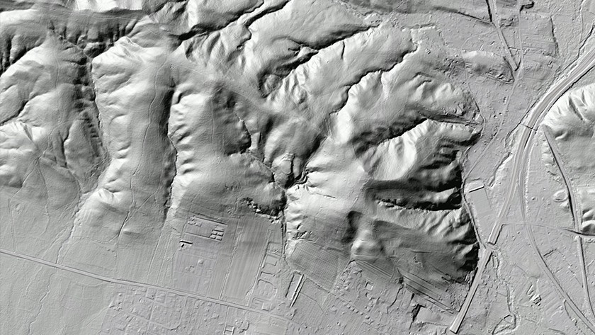
LiDAR
LiDAR (Light Detection and Ranging) is a technology most people probably associate with increasingly popular autonomous vehicles. However, in geodesy and archaeology, laser beams play a somewhat different role.
In simple terms, we are interested in the ability to “see” beyond tree canopies, beneath grasses, and to detect features that help determine what we are dealing with.
Importantly, we do not need an aircraft or extremely expensive equipment. Even a more affordable drone equipped with a laser sensor — or building your own measurement device, which is now entirely possible at home — is not necessary.
For several years now, ready-made maps have been available via Geoportal. More advanced users can also access the point cloud view and download the data for their own processing.
An unknown hillfort?
Combining the two aspects mentioned above — long hours spent searching the area for interesting and not always well-known sites, and the winter dormancy of vegetation improving field visibility — the chosen destination was an object we had virtually identified years ago but had never had the opportunity (or sometimes the motivation) to inspect up close.
Located less than an hour’s drive from Kraków, strategically positioned, protected on three sides by natural terrain and with access to significant water resources — this is almost a textbook recipe for a hillfort.
Is that really the case? That remains to be seen. In this particular location, there are no helpful markings of a recognized site in the available literature, no references in local spatial development plans, and no entries in publicly accessible resources of the Archaeological Museum in Kraków or the National Institute of Cultural Heritage.
Of course, it should be assumed that the site is known. However, we were unable to find the relevant information — or the institutions have not yet published it due to lack of time, funding, or in order to protect the site pending research.
There is still much to discover
Although it may be hard to imagine, history and the ground still conceal vast numbers of prehistoric and much younger sites. The fog of mystery surrounds not only poorly visible terrain features but also objects perfectly outlined on maps — and sometimes even present in written sources.
Possessing the right tools and data changes little on its own. Someone still has to analyze them, notice subtle details, and connect the dots.
An example from our area of interest is the hillfort hidden until recently in the Zagórskie Forests near Kielce. The site was identified only in 2018. You can, of course, also find it on the 100KRK map (Hillfort in Zagrody). Due to the niche and relatively recent nature of the topic, we came across it while reviewing what the laser had “revealed” from the forest.
The assumption was simple — the Warsaw route, which had played an important communication role since time immemorial, must have been monitored and controlled. The scarce data on power centers could only be explained by the current state of knowledge — or rather its absence. And so, through deduction and a “textbook recipe” for hillforts, we arrived at a rather unusually located site whose character was later confirmed by located publications.
LiDAR in 100KRK
Using the LiDAR view — more precisely, terrain hillshading — in Geoportal, due to the number of layers and services, is not the most convenient experience. It can even be somewhat cumbersome. This is why the idea to implement this solution in 100KRK emerged almost simultaneously with the project itself.
Although the first public release of the service appeared after about a week of work in early February 2026 — and it still lacks even a few solid blog posts and the initially planned set of objects — we can already report that the map layers are ready and include the discussed terrain hillshading.
These changes will be published in the coming days. While reading this text, check whether the icon enabling selection of the preferred view is already visible in the bottom-right corner of the screen.
In addition to hillshading, a standard OpenStreetMap view will also be available, and in later development stages, an orthophoto map as well. Whether these options will actually be widely used remains a question for our visitors.
What’s next for the presumed hillfort?
It is difficult to assume that an object in such an interesting and fairly obvious location — with LiDAR features that can be interpreted as rampart remains — has not yet been identified. Concealing it to protect against treasure hunters would therefore be of rather questionable justification.
For this reason, we will publish our hypotheses in the next post and simultaneously seek information at the source — the WUOZ.
One thing is certain: if the unnatural landform recorded both virtually and in the field does indeed turn out to be an archaeological site, it is undoubtedly a forgotten one. And we will do our best to change that 😉